
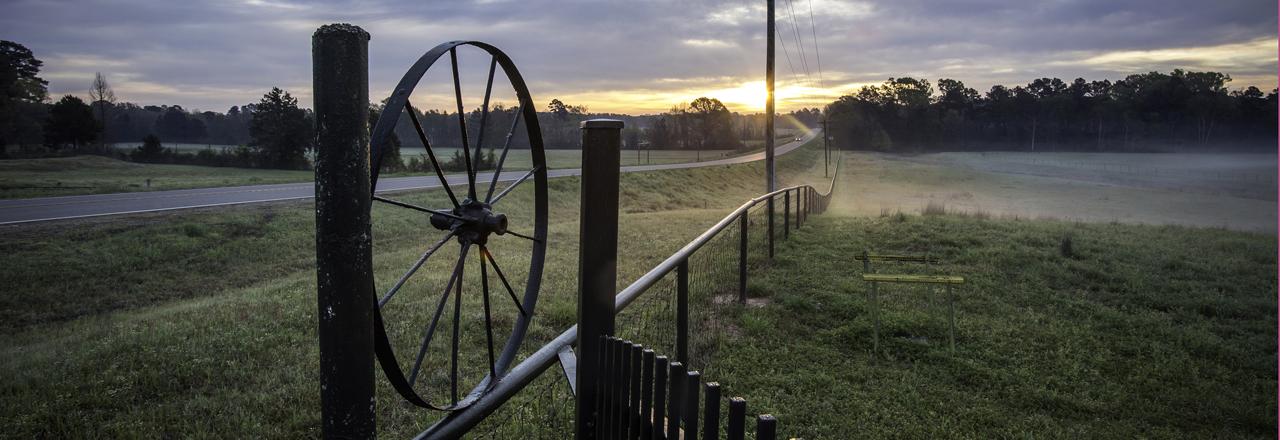
History abounds in Toledo Bend Lake Country. See historical markers throughout the area.
|
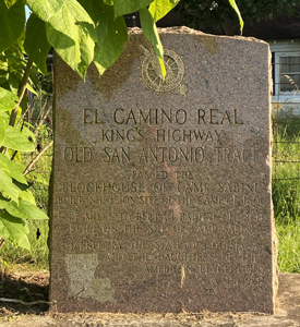
El Camino Real - The King's Highway Historical Marker Many, Louisiana (Sabine Parish) - Along the San Antonio Trace The Sabine River was the western boundary of the neutral strip from 1806 to 1820. The site was marked by the State of Louisiana and the Daughters of the American Revolution in1951. Link 1 from the Historical Marker Database |
 |
|
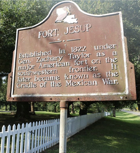
Fort Jesup Historical Marker Many, Louisiana (Sabine Parish) Established in 1822 under Gen. Zachary Taylor as a major American fort on the southwestern frontier. It later became known as the Cradle of the Mexican War. The site is about 125 yards from the Historical Park and Old Fort Jesup. |
 |
|
Pendleton Crossing Historical Marker Many, Louisiana (Sabine Parish) Entrance to controversial Neutral Strip bounded by Sabine River West and Arroyo Hondo East. It was claimed by the U.S. after Louisiana Purchase, 1803, and by Spain as the ancient boundary of Mexico. |
 |
|
History of Toledo Bend Historical Marker Many, Louisiana (Sabine Parish) As a result of rapid industrial development and the changing demands of an evolving economy during the late 1940s, the people of the Sabine River area, both in Texas and Louisiana, realized a need to provide for the future of the area. The Sabine River Authority of Texas and then Louisiana were created to develop the waters of the Sabine River Basin. Toledo Bend is the largest man-made body of water in the South, and was constructed for water supply, hydro-electric power generation, and recreation. |
 |
|
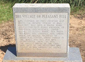
Village of Pleasant Hill Historical Marker (Front) Many, Louisiana (Sabine Parish) The Village of Pleasant Hill was founded at this location just inside the DeSoto Parish in 1846. Pleasant Hill was a major road intersection with roads radiating to Mansfield, Natchitoches, Grand Ecore, Ft. Jessup, Many, Red River (Pleasant Hill Landing), and Sabine River. The village migrated to Sodus R.R. Station, Sabine Parish in the 1880's and 90's and was incorporated there in 1896. The largest battle of the Civil War west of the Mississippi was fought in and around the village on April 9, 1864. |
 |
|
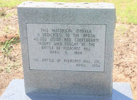
Village of Pleasant Hill Historical Marker (Rear) Many, Louisiana (Sabine Parish) The Village of Pleasant Hill was founded at this location just inside the DeSoto Parish in 1846. The back of the marker is inscribed - "This Historical Marker is dedicated to the approx. 40,000 Union and Confederate troops who fought in the Battle of Pleasant Hill." |
 |
|
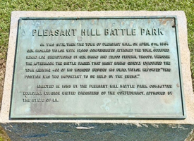
Battle of Pleasant Hill Historical Marker Old Pleasant Hill, Louisiana (DeSoto Parish) On this site, then the town of Pleasant Hill, on April 9th, 1864 Gen. Richard Taylor with 12,000 Confederates attacked the town, occupied behind log breastworks by Gen. Banks and 25,000 Federal troops. Through the afternoon the battle raged. That night Banks quietly evacuated the town leaving 400 of his wounded besides his dead. Taylor reported "This position was too important to be held by the enemy. |
 |
|
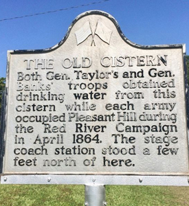
The Old Cistern Historical Marker Old Pleasant Hill (DeSoto Parish) Both Gen. Taylor's and Gen Banks' troops obtained drinking water from this cistern while each army occupied Pleasant Hill during the Red River Campaign in April 1864. The stage coach station stood a few feet north of this location. |
 |
|
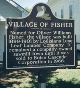
Village of Fisher Historical Marker Fisher, Louisiana (Sabine Parish) Village of Fisher. Named for Oliver Williams Fisher, the village was built 1899-1901 by Louisiana Long Leaf Lumber Company. It remained a company-owned sawmill town until it was sold to Boise Cascade Corporation in 1966. More information from the National Register Database Map |
 |
|
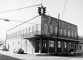
McNeely Hotel 690 San Antonio Avenue, Many, Louisiana This site is on the National Register of Historic Places. More information from the National Register Database Latitude & Longitude: 31° 34' 5.942676", -93° 29' 5.645148" |
 |
|
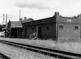
Kansas City Southern Railway Depot 750 W. Georgia Ave., Many, Louisiana This site is on the National Register of Historic Places. More information from the National Register Database Latitude & Longitude: 31° 33' 50.953212", -93° 29' 3.392952" |
 |
|
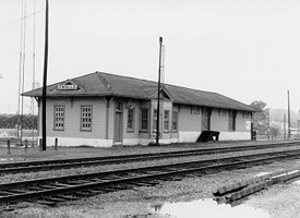
Kansas City Southern Depot Spanish and Port Arthur Sts., Zwolle, Louisiana This site is on the National Register of Historic Places. More information from the National Register Database Latitude & Longitude: 31° 37' 50.791008", -93° 38' 35.9016" |
 |
|
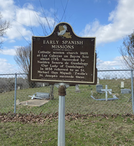
Early Spanish Missions Historical Marker Catholic mission church built at Las Cabezas on Bayou Scie about 1795. Succeeded by Nuestra Senora de Guadalupe (Our Lady of Guadalupe). In 1858 referred to as St. Michael (San Miguel). Zwolle's St. Joseph's succeeds these. This site is on the National Register of Historic Places. More information from StoppingPoints.com Latitude & Longitude: 31.617407, -93.641118 |
 |
|
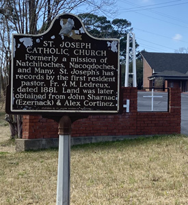
St. Joseph's Catholic Church in Zwolle, LA Parish History Church Information
|
 |
|
JM Miller & Brother Store 7886 LA 473 , Florien, LA, USA This site is on the National Register of Historic Places. More information from the National Register Database Latitude & Longitude: 31° 18' 8.98596", -93° 32' 8.790396" |
 |
|
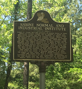
Sabine Normal and Industrial Institute Historical Marker Saline Road off San Patricio Road (Sabine Parish) For more information, read The Community of Saline By Rolanda Teal Edmund Belton: Founder of an African American Community in Sabine Parish |
|
Sabine Parish High School Revitalization Project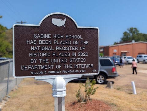
850 Highland Avenue Many, LA
Sabine High School was a K-12 school for African Americans in Sabine Parish until desegregation in 1970, when parish officials redesignated it as Many Junior High School. The facility was closed in 2001 and listed on the National Register of Historic Places in 2020.
When rehabilitation is completed, the campus of Sabine High School will serve as a multi-purpose community center complex for northwest Louisiana and once again be a beacon for the community and region.